Thursday, August 27, 2009

Stuart Highway - 24 to 26 August 2009

We travelled north on the Stuart Highway, following the route of the tough Scottish explorer John McDouall Stuart who blazed the way for the Overland Telegraph. This Highway is has many significant sites commemorating the history of Stuart, the Telegraph and World War II.

Just north of Alice Springs we crossed the Tropic of Capricorn - so now it is official - we have gone "Troppo"

The Stuart Highway was a dirt track until WW2 when the need to move troops and goods back and forth from Alice Springs where the Ghan terminated meant the track deteriorated badly under constant traffic and the road was bitumenised. All the States Public works departments were assigned a section.


Shortly after we stopped to move a dead Kangaroo further from the road to help protect the Wedge Tail Eagles which are killed in increasing numbers as they rise into the path of cars after feeding on the carcass.


We stopped for coffee at the Aileron station roadhouse and admired the aboriginal art and the huge [12 meters high] sculptures of the Anmatjere man, woman and child and Hollywood style sign erected by the Alice Springs sculptor Mark Egan.

We then passed the marker for Central Mount Stuart which Stuart calculated as the point equidistant from North, South, East and West coasts and thus in his view the centre of Australia.


At Barrow Creek there is a well preserved Overland Telegraph repeater station. It gives a sense of the isolation and scale of undertaking to construct the line in the space of two years less than ten years after the country was first explored. It was an amazing technological feat to connect Australia to the rest of the world in that era and through that rugged country.


Our overnight stop was at Wycliffe Wells the unofficial UFO Capital of Australia. Unfortunately no luck in seeing a flying saucer. However we drove to watch the sunset at the Devils Marbles which was wonderful.


From Wycliffe Wells we drove to Tennant Creek, a town which arose from a 1930's gold rush. At Tennant Creek we saw the Battery Hill Mine and the Old Telegraph Office.


There is a great social history display which shows how hard it was to be a miner and miners family in such a remote mining town where initially the water had to be shipped in 44 gallon drums.

Outside Tennant Creek we came to the Three Ways, the intersection of the Stuart and Barkly Highways and the site of another memorial to the Rev John Flynn.

We then detoured to Newcastle Waters, the junction of the North South Murranji and East West Barkly stock routes from the days when drovers moved cattle to the seaboard markets. It had a Stockman's Memorial and the Junction Hotel built for "free" by a group of the hoteliers creditors out of disused windmills on stock bores.


There is also an AIM Church built from a Sydney Williams Hut or Comet hut. These were used to house the troops during WW2
From there we drove to Daly Waters. This has an historic pub and serves a great Barra and Beef Barbecue.

It has Australia's most remote traffic light - always red and always ignored, but fortunately no sign of Australia's most remote traffic policeman.Daly Waters is also the site of Australia's first International Airport and the hangars and terminal remain. It is also the site of what remains of an "S" carved by Stuart on a tree nearby, almost impossible to see and impossible to photograph.


From Daly Waters we drove to Katherine, stopping for lunch at Mataranka to see the "Big Termite" mound and swim at the Mataranka Springs [created by soldiers in WWII without the need for an Environmental Impact Statement] and then at the naturally occurring Bitter Springs.


Bitter Springs is in Elsey National Park.

Mataranka is where the Elsey Homestead was located. Mrs. Aeneas Gunn wrote ' We of the Never Never' and 'Little Black Princess' about her experiences here.
Never never means never never go there or never never leave depending on your point of view.


Friday, August 21, 2009

Ayers Rock, Olgas, Kings Canyon - 18 to 21 August 2009

At Yulara we stayed at the Ayers Rock Camping Park and saw Uluru [Ayers Rock at sunrise and sunset.


We drove to Kata Tjuta [The Olgas] which means many heads and walked through the Gorge

At Kings Canyon we stayed at the Kings Canyon Resort in the Watarrka National Park and did the rim walk. 


The next day we drove back to Alice Springs via the Mereenie Loop Road which passes through Aboriginal Land for which a fee is paid.

We debated the meaning of this government sign.

The owners provided clarity at both the start 


and finish of a dangerous curve in the road


The Meerenie loop brought us to what was the Hermannsburg Lutheran Mission established on the Finke River in 1877.

Monday, August 10, 2009

Dalhousie to Alice Springs - 8 - 10 August


We drove from Dalhousie via Oodnadatta to Hookeys Hole where we camped with another Bushtracker family. We saw our first wild budgies and lots of pink Galahs.


The next day we drove through the Painted Desert to Arckaringa Station, where we camped for the night. We had time to drive back into the Painted Desert and enjoy the sunset sitting on a rock. This was very special.


The next day we drove through the Copper Hills and overnighted at Erldunda Roadhouse a good transit Camp. They have all pull through sites and serve a good dinner.


We then finally made the Northern Territory border after almost three months in South Australia.


From there we drove to the MacDonnell Range Holiday Park in Alice Springs.

Friday, August 7, 2009

Dalhousie Springs – 6 and 7 August 2009


We drove from Oodnadatta to Dalhousie Springs passing the Perdika Siding and ruins, once a stop on the old Ghan and the ruins of the old Dalhousie Homestead. These places were truly remote although they had their own racetrack. Picnic races were very much a part of the social scene on these Stations.

Dalhousie was made a National Park when it was found that grazing was degrading the Springs. The old homestead is like an oasis with its date palms and springs.

The road in can only be described as "ordinary". As we drove into Dalhousie a man came up to Tricia and said I knew it had to be a Bushtracker when it came around the corner. Dalhousie is the beginning and end of the Simpson Desert track and our neighbour who had just crossed the Simpson in both directions seemed more impressed that we had brought the van in.

There are many mound springs in this area which can be visualized as an upside down shower head, formed by water being forced at pressure from the Great Artesian Basin.

Dissolved chemicals precipitate to form the mounds. The Basin is recharged from rain water in Queensland which moves south percolating through limestone rocks.

Dalhousie Spring comes from deep down and is very warm [37 to 43 degrees Centigrade] and beautiful to swim in. The water is thought to be about 3 million years old.


John thinks we would pay a lot for this anywhere else, a massage on the road in followed by a hot spa.

The main spring is about 100 metres by 50 metres and although the water is deep in many places you can also stand with just your head out.

Wednesday, August 5, 2009

Oodnadatta - 5 August 2009


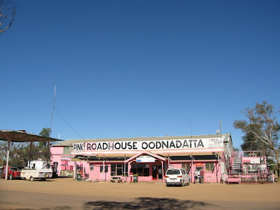
We left William Creek and drove to Oodnadatta where we stayed at the Pink Roadhouse. Oodnadatta means Mulga flower. Oodnadatta was for many years the rail head of the Ghan. It had a Hospital and an Aerodrome and was a very busy place. Camel Trains started from here and went to Stations up to 1400 kilometers further out. In 1928 the rail was finally built through to Alice Springs and Oodnadatta lost its importance.The Station is now a museum.

Now we are truly off road the Darwinian law of caravans is starting to apply. Throughout our trip we have seen thousands of caravans but only three Bushtracker vans. On the Oodnadatta track we have seen only four full size vans, plenty of camper trailers and two Kimberly Kamper vans. Of the four full size vans three have been Bushtrackers!

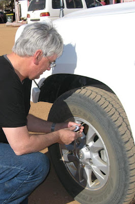
Following advice from the owner of the roadhouse we adjusted the tyre pressures in the Land Cruiser and the Van - 20 psi front and 26 psi rear on the Land Cruiser and 24 psi on the Van. Somehow tyre pressures did not go metric. It does make a difference, reducing the risk of stone damage and the modern tyres seem to take the flexing and not overheat. Mind you speeds for us are low, never more than 70 kph [42 mph] and sometimes as low as 10 kph [6 mph]


Tuesday, August 4, 2009

William Creek and Lake Eyre redux - 3 and 4 August 2009

From Coober Pedy we drove to William Creek. William Creek was once the dinner stop on the Ghan. While the train loaded coal and water the passengers ate dinner. The decline of William Creek began when dining cars were installed on the Ghan.


Today, William Creek is just one hotel and a stop for those crossing the Simpson Desert, heading further North or going to see Lake Eyre, with an occasional road train.

It is also within Anna Creek Station part of Sydney Kidman's Cattle Empire. Anna Creek is the world’s largest working cattle Station. At 6,000,000 acres it is larger than Israel. It is largely destocked at the moment as it is in drought.


We had dinner at the William Creek Hotel. The meal is ordered when you book. We were served dinner by a nice young Canadian Woman. Since we have been in the outback we have been served by a United Nations of young women. If they spend 88 days working in Remote and Rural Locations they can possibly extend their visa by a year.

  This is a standpipe. The pink Galah's are a favourite, colourful and playful in flocks.
 
 
The next day we drove to Heligan Bay and ABC Bay at Lake Eyre. This was a rough road but the scenery was worth it. We had a picnic at Heligan Bay.

We were lucky to see a Lake Eyre Lizard a native of the salt pans.


The sign on the road to William Creek is explicit. As Trish took the photo a young Frenchman in a beat up combi van stopped - shrugged his shoulders and said he had nozzing on the list - and then drove on.


Perhaps only Austrian tourists die, this grave of Caroline Grossmeuller is on the road to Lake Eyre from William Creek.


Monday, August 3, 2009

Coober Pedy – 31 July, 1 and 2 August 2009

 From Wirraminna we drove to Coober Pedy – the Opal capital of the world - staying at the Stuart Ranges Camping Park.

Mining on a large scale started after World War I – and the ex-Diggers faced with lack of timber and used to living in trench occupied the failed mines. The local aborigines thought these men were the ghosts of their ancestors who had lost their colour, and called them Kupta Piti loosely translated as white men jumping out of holes. This became Coober Pedy.


Next day we took the Stuart Tour. This was a fabulous tour with a wealth of information.


We saw the Breakaways and gazed out on what was once the bottom of the ocean bed many millions of years ago. We saw moon rocks and the moon plain. We also saw rocks made of fossilized salt water. Moon rocks are very popular for decorating the above ground buildings.


We stopped at the dog fence which is designed to keep the dingoes north.


We visited the Serbian Church, an underground church that is world heritage listed [only twelve years after it was built], and the only one we know of with a bar.

When you look at this hill every vent has a room underneath it. Air goes out through the small vents. The larger vents pull air in very slowly and it is either warmed or cooled by the rocks depending on the season.


Correctly done the temperature will remain between 23C [73F] and 25C [77F] degrees all year round. This is why underground living is so popular here as the ambient temperatures on the surface vary from -2C [28F] to 65C[149F].

We saw an old time dugout, very dusty, and a modern dugout which is finished with silcrete to eliminate the dust. A new dugout it is left for a year or more so the rock dries out. Otherwise there are constant problems with damp. Houses can be as grand as you want; all you have to do is dig another room and as miners these guys are pretty good at that. One has an indoor lap pool and shooting range for his high powered rifle. And noise from parties stays indoors.

 
The vacuum cleaner truck [a local invention] sucks excavated rock from the mine. When the drum fills the vacuum is blocked, the drum base opens and empties the drum thus restarting the vacuum and sucking the drum base closed again. All the mine dumps are about 10% opal and a popular pastime is noodling for opal, that is sifting through the piles of rubble and seeing what you can find. Noodling can be dangerous because of all the mine holes and because the dumps are inherently unstable.


When a seam of opal is found, it still has to be mined by hand.

Opal is formed from a solution of silicon dioxide and water. As water runs down through the earth, it picks up silica from sandstone, and carries this silica-rich solution into cracks and voids , caused by natural faults or decomposing fossils. As the water evaporates, it leaves behind a silica deposit. This cycle repeats over very long periods of time, and eventually opal is formed.

Golf, mostly played at night with glowing balls, is on a course which replicates Royal St Andrews minus the grass. This is the only golf course which has reciprocal rights with St. Andrew Golf course

Before leaving we filled our tanks, water is scarce here. It comes from a bore into the Great Artesian Basin and reverse osmosis is used to make it drinkable. This means they have great water but they charge for it.

Main street Coober Pedy. The Desert Cave Hotel has some dugout rooms and excellent coffee